
Good Fences: Westport’s borders, boundaries and stone markers
Posted on December 5, 2022 by Jenny ONeill
By Mark Allen
Ever since I was a child, my family played a game while heading down the American Legion Highway. Surely you’re familiar with it, and if not, it’s a fun tradition to start. Without fail, every time we drive through the few dozen feet between Westport and Tiverton, we hold our breath through Fall River. Even if you don’t play along, you’ve at least asked yourself, “why, oh, why does this ridiculous stretch exist.” If your first guess was that it was some relic of the Colonial Days, you’re more right than you had any idea.
One of New England’s great geographical cliches is the stone walls. They have dotted and divided our countryside for 300 years and serve an understandable purpose. Our forefathers cemented their control over the land they themselves pacified by erecting such near immovable boundaries. Maps were rare and comedically inaccurate, so a line of stones (also known as witness monuments or witness marks) demarking the distinction between two plots was far more reliable than a line of ink. However, this was not always practical due to the landscape or sheer size of a property, so instead, one could create boundaries with landmarks. Streams and prominent trees proved to be common markers in the unfettered frontier, though these options had repercussions. The stream could dry up, or the tree could fall, and the following confusion and disputes prove Robert Frost’s parable that good fences make good neighbors. Therefore, when possible, landowners would instead commission stone markers that could stand the test of time. While not as effective nor iconic as an entire wall, stone boundary markers dot the New England landscape; their Stonehenge-like character provides an undeniable mystique to those who do not know their story.
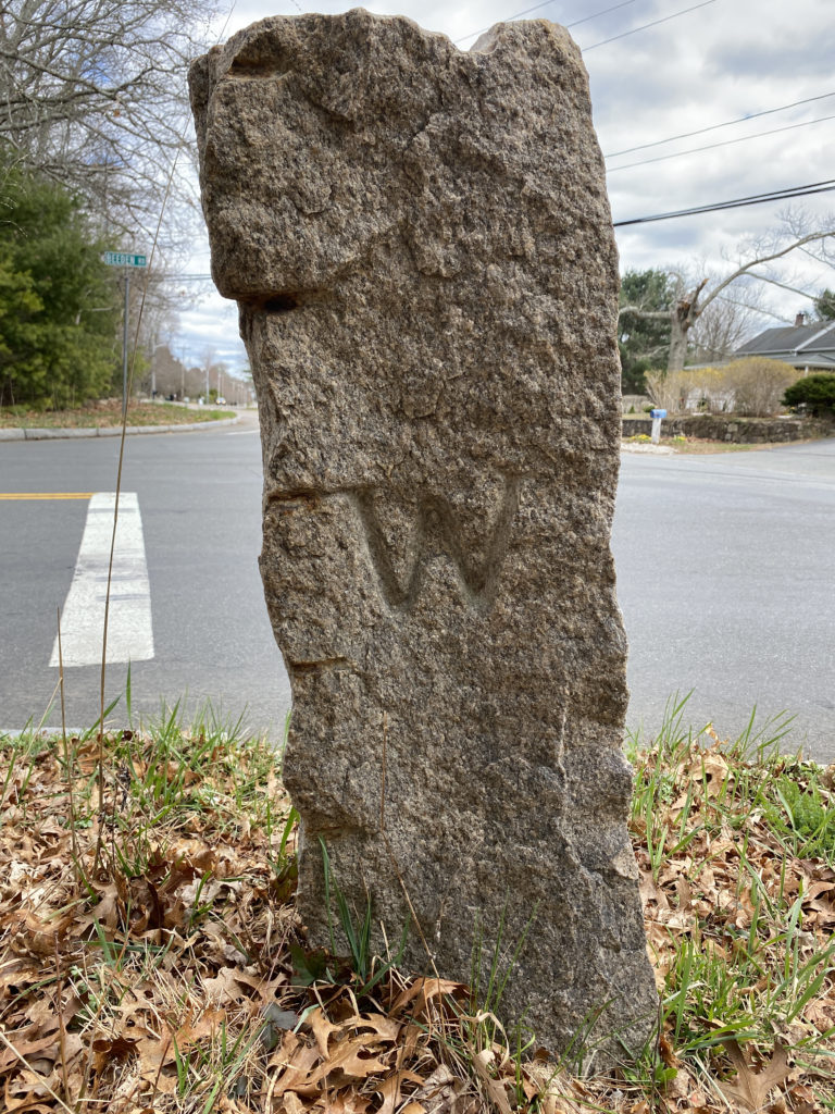
Stone marker located at Old county road and Beeden Road 2022
Such is the case with Westport’s own collection of stone markers. At first glance, these short obelisks located throughout the borders of our town look seemingly haphazard. Though weathered by the years, these two-foot granite stumps still have perfectly legible letters, most commonly a “W” on one side and an “NB,” “FR,” “D,” or “RI” on the other. As you may guess, these are not anyone’s initials.
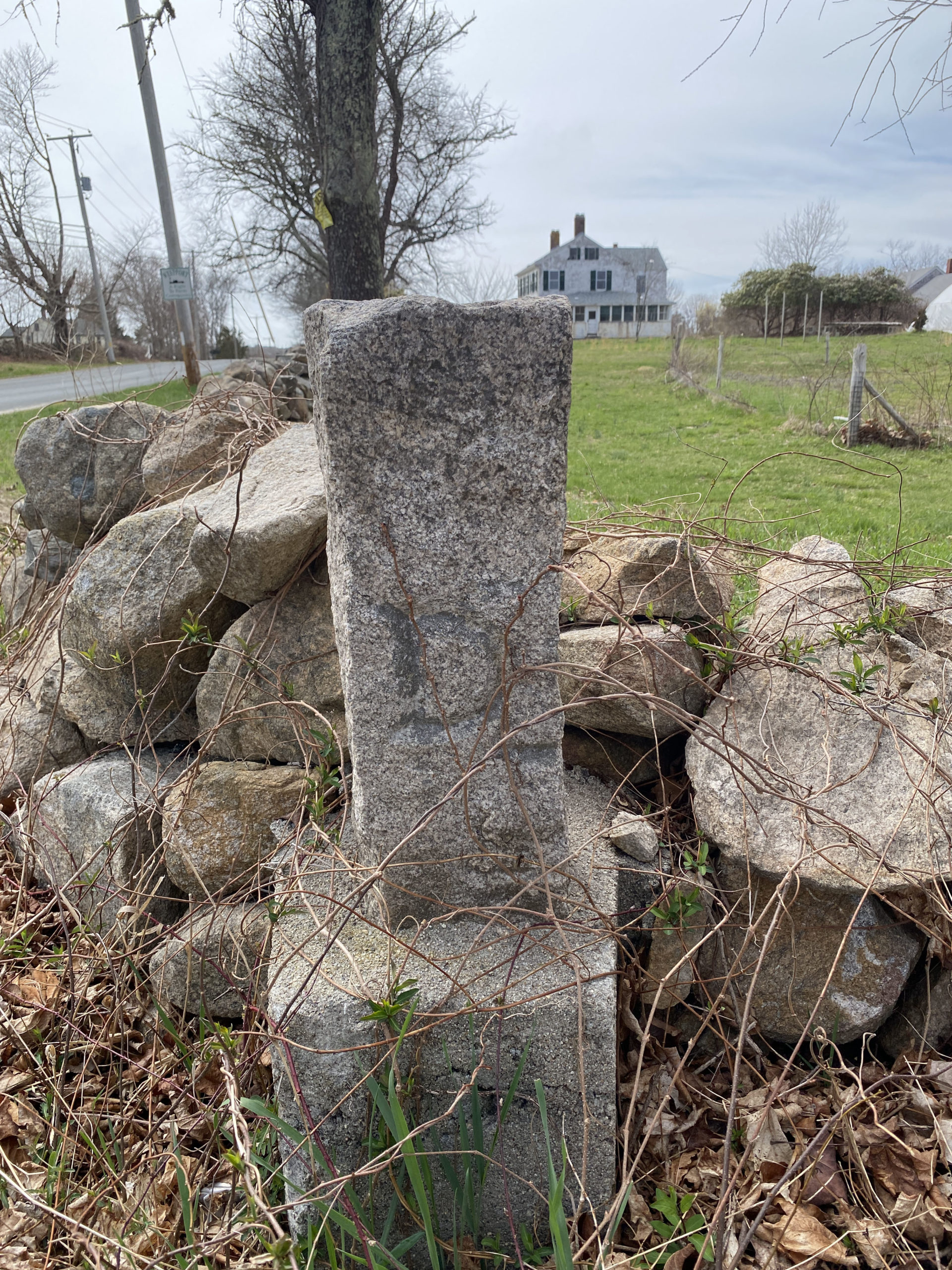
Stone marker located at Horseneck Road and Division Road 2022

Stone marker located at Division Road
Instead, towns, counties, and even states use the same tools to demarcate boundaries for private individuals for the same reasons. Inaccuracies on a map or a misworded document can lead to unnecessary disputes, and there have been more than plenty in our region. For example, disagreements on the Massachusetts/Rhode Island border date back to the 1600s, when it was decided that the border would be at a “Narragansett River” that never existed. Thus began a two-hundred-year legal battle that had to be resolved by the Supreme Court. Therefore, the traditional methods were utilized by governments while drawing boundaries to ensure they made sense. See the Dartmouth/New Bedford Border, which after being redrawn in 1831, used one particular maple tree as the sole reference point for a mile-long imaginary line. Much like fence viewers would inspect the boundaries between citizens’ property to ensure they were well-drawn and maintained, both townships would have sent representatives down to this particular maple tree and have them walk the borders to check if the legal boundaries needed revision.
As was the situation in 1894, when the state commissioned an investigation to “… locate and define the boundary lines between the city of Fall River and the town of Westport.” The Massachusetts Topographical Survey Commission combed through archives dating back to the region’s first colonization to determine where Fall River was legally supposed to end. The city’s awkward growth involved buying and trading vast amounts of land from Rhode Island, complicating matters.
To give you an idea, in 1746-7 our county capital of Bristol was essentially traded for lands that would become southern Fall River. Tracking down the true border became vital as Rhode Island wished to completely redraw its eastern flank in five years, finalizing it with geographical coordinates and the most accurate tools at hand. If Massachusetts could not resolve its internal boundary predicament in the region, they were sure to lose territory.
The Commission’s final verdict was certainly interesting. They tracked down the markers of old in the name of fairness and drew straight lines between each one. Bodies of water were cut in half, and while the geographic coordinates of the boundaries’ various intricacies were recorded, their final locations remained the same. However, “appropriate monuments” were erected at all the various nooks and corners along the border, replacing the anointed maple trees of old. These granite slabs are the ones we see today, and although they are barely 130 years old, they still look positively ancient at first glance. This was the exact point: heavy and immobile, one cannot move the borders easily and should not do so needlessly.
The atlas of the boundaries of the cities of Acushnet, Berkley, Dartmouth, Dighton, Fall River, Fairhaven, Freetown, New Bedford, Somerset, Swansea, and Westport published in 1904 by the Harbor and Land Commissioners contains a wealth of information. Their fieldwork involved identifying town corners using some surprising principal triangulation stations which included finials or vanes on the top of cupolas:
- Tripps Barn Cupola. Finial of cupola on barn on estate of David R. Tripp. Westport on road leading from Lawtons Corner in Westport to Bliss Corner in Tiverton.
- Hicks Barn Cupola. Vane rod and ball on low, square cupola on wooden barn situated on estate of G. A. Hicks on westerly side of the “Cross road,” Dartmouth.
- Davis’s Barn Cupola. Vane rod on small square cupola on barn on the estate of Mrs. Rhoda Davis, on the Butter and Cheese Brook road, east of its junction with the road leading to Westport factory, Westport.
The atlas includes detailed maps and descriptions of town corners and the monuments marking these corners. For example:
“DARTMOUTH- WESTPORT 1 AND W.M.
LOCATION. -The corner is an unmarked point at the intersection of the center line of the Dartmouth- Westport line road with the southerly side line of the road between Fall River and New Bedford. It is north 52° 45′ east and 29 feet distant from the witness mark, which is situated at the southwesterly corner or the two roads, being 6 feet from the westerly end of the culvert at that point.
MARK. – The witness mark is a rough split granite monument 4.75 feet in height and about 9 x 10 inches in section; it has stones piled around its base. The letter W is cut on the west face and D on the east face.”
Folio 19 Dartmouth Westport corners
While one can scoff at a scenario such as this – a room of legal scholars and map enthusiasts moving lines half a millimeter at a time – the real-life implications of a poorly drawn map cannot be ignored. Commissions like this are why we can hold our breath through Fall River. The old marker indicating the southern extreme of Fall River was at the southern end of Sawdy Pond, and therefore, the Commission decided to draw the line exactly north from it, cleaving the pond in half between the two towns. This decision had some bizarre consequences, as Fall River gained jurisdiction over several small neighborhoods that are entirely unconnected from the city proper. Most notably, the 200-odd feet of the American Legion Highway from the Pond’s halfway point to the Rhode Island border. A ridiculous patch, you can quite literally see the “Entering Tiverton, Rhode Island” sign from “Entering Fall River.” In this way, their “Stonehenge–like quality” comes into full effect, and these mysterious totems reveal their true power. While maple trees or concrete slabs on their own may be no more than momentary curiosities, for 400 years, they have been ordained with extraordinary powers, dictating lives – or at least land – ever since.
Additional references
The following is extracted from the Atlas of the boundaries of the cities of Fall River – New Bedford and towns of Acushnet, Berk[e]ley, Dartmouth, Dighton, Fairhaven, Freetown, Somerset, Swansea, Westport, Bristol County, 1904.
Access the compete atlas at this link: http://hdl.handle.net/2452/47859

Folio 19 Dartmouth Westport corners
Folio 18 Dartmouth Fall River Westport corners. Click on image to enlarge.

Folio 22 Dartmouth Westport corners. Click on image to enlarge.
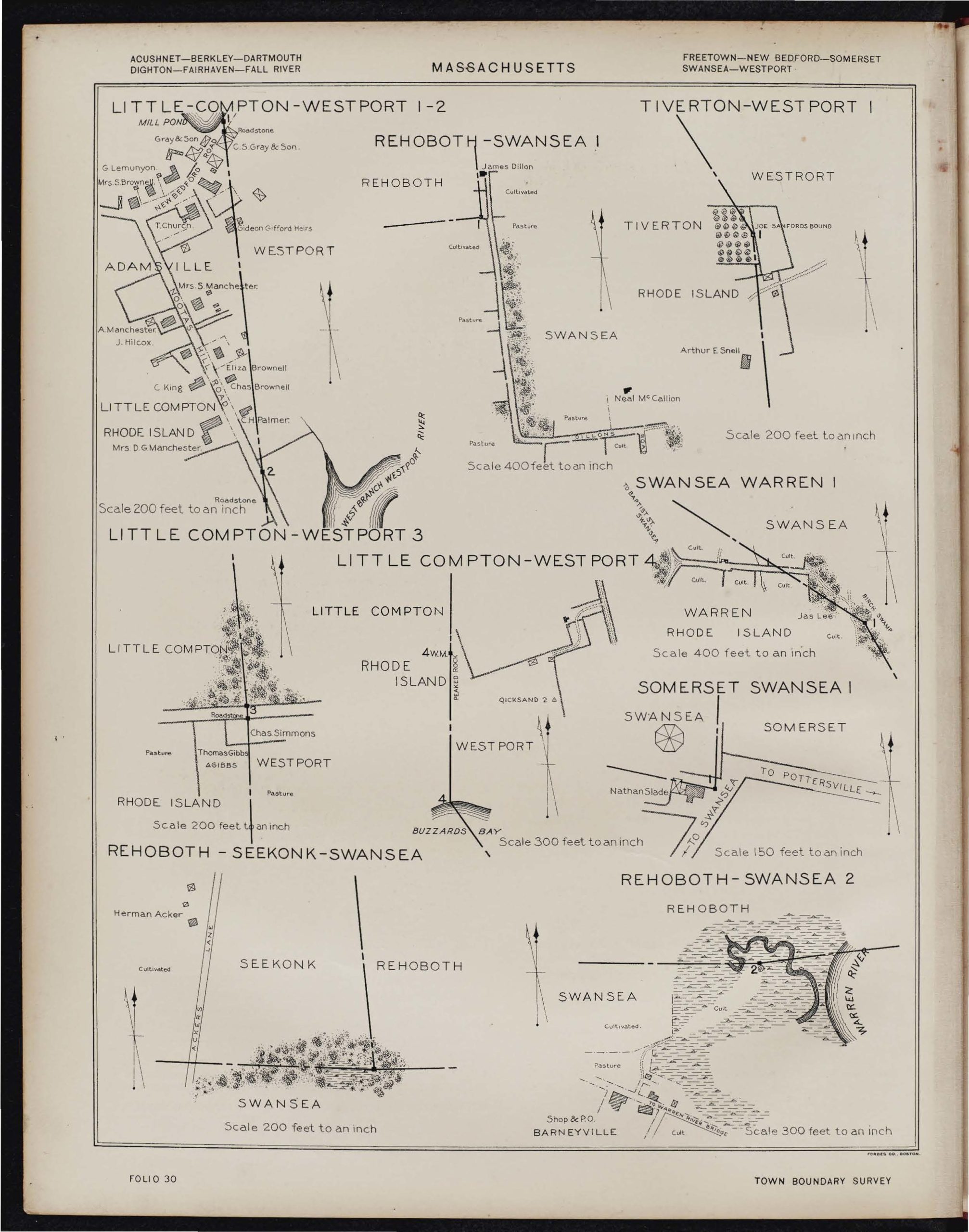
Folio 30 Little Compton Westport corners. Click on image to enlarge.
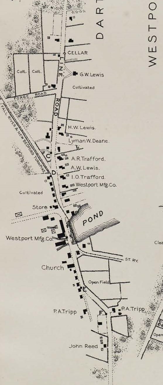
WESTPORT. The town of Westport was incorporated by the Statutes of 1787, chapter 9, being made up of the westerly part of Dartmouth and extending from the old County road, known as the” Line road,” on the east, to the line between the Commonwealth of Massachusetts and the State of Rhode Island on the west. The portion bordering on Fall River, along the North and South Watuppa ponds, was established by the Statutes of 1894, chapter 478. The balance of the westerly line, following the boundary line between the Commonwealth of Massachusetts and the State of Rhode Island, was re-defined and marked under authority of Massachusetts Statutes of 1899, chapter 476, and a similar act, – chapter 683 of the Acts of 1899 – was passed by the State of Rhode Island. The tide-water line between Massachusetts and Rhode Island was established by the Statutes of 1883, chapter 11 3, and a similar act-chapter 417 of the Acts of I884-was passed by the State of Rhode Island. The other tide-water lines were established by the Harbor and Land Commissioners under authority of the Statutes of 188 I, chapter 196
Present boundaries 1904
LINE BETWEEN THE TOWNS OF DARTMOUTH AND WESTPORT.
(SEE ALSO TIDE-WATER BOUNDARIES.)
Beginning at the corner of Dartmouth, Fall River and Westport, a rough split granite monument, triangular in section, marked W FR D and situated in a wall surrounded by a heavy growth of woods, at a point 2/3 of a mile north of the junction of the Fall River and New Bedford roads with the Westport road; thence south 70 08′ east 3476 feet to corner1,
an unmarked point at the intersection of the southerly line of Bread and Cheese Brook road with the center line of the Dartmouth – Westport Line road, north 52 degrees 45′ east and 29 feet distant from the witness mark, a rough split granite monument marked W D and situated at the southwesterly junction of the Dartmouth – Westport Line road with the Bread and Cheese Brook road; thence south 37 degrees 45′ east 5 and 29 feet to corner 2, an unmarked point in the center of the Dartmouth – Westport Line road, north 52 degrees 45′ east and 27.5 feet distant from the witness mark, a rough split granite monument marked W D and situated on the westerly side of the wall, on the westerly side of the road; thence southerly, along the center of the Dartmouth Westport Line road, about 66,000 feet to corner 3, an unmarked point in the center of the road, about 88 feet from the high water line of Buzzards bay and about 20 feet east of the witness mark, a rough split granite monument marked W D and situated 2.5 feet east of the wall on the westerly side of the road, at a point where the road turns westerly along the shore towards Gooseberry neck; thence southeasterly, along the center line of the road produced, to corner 4, an unmarked point in the low-water line off Horse Neck beach. (For continuation, see tide-water boundaries.)
LINE BETWEEN THE CITY OF FALL RIVER AND THE TOWN OF WESTPORT.
Beginning at the corner of Dartmouth, Fall River and Westport, a rough split granite monument, triangular in section, marked W FR D and situated in a wall surrounded by a heavy growth of woods, at a point 2/3 of a mile north of the junction of the Fall River and New Bedford roads with the Westport road; thence north 76° 12 ‘ west 8,161 feet to corner 1, a rough granite monument marked FR w and situated on land of Stephen Borden, 2 feet south of a wall on the southerly side of a cart path leading westerly from the East road near David Pettee’s house; thence due west about 2,380 feet to corner 2, an unmarked point in the water space of North Watuppa pond; thence southerly to corner 3, a light-colored granite monument marked FR W 1896 and situated on the southerly side of Pleasant street, at the center of the stone arched bridge over the channel connecting North and South Watuppa ponds and known as “the Narrows;” thence along a straight line through South Watuppa pond to corner 4, an unmarked point at the southern extremity of South Watuppa pond, at the mouth of Stony brook; thence, along the center of Stony brook, to corner 5, an unmarked point in the center of Stony brook, at the northern extremity of Sawdy pond and about 1,425 feet south of the road from Bliss Four Corners to New Bedford; thence along a straight line through Sawdy pond to the corner of Fall River, Tiverton and Westport, a granite monument marked R.I. MASS. R.l. 1861 and situated in a young growth of woods, at the line of highest water, at the extreme southern point of Sawdy pond, on land of Clarinda Potter, about 850 feet north of the ‘Westport road.
LINE BETWEEN THE TOWNS OF LITTLE COMPTON (R.I.) AND WESTPORT.
(see also tide water boundaries. )
Beginning at the corner of Little Compton, Tiverton and Westport, an unmarked point in the Massachusetts – Rhode Island boundary line, where the northerly line of Little Compton and the southerly line of Tiverton intersect the same, being about 3/4 of a mile north of the village of Adamsville; thence south 5° 19′ east to corner I, a granite monument marked “MASS. ,R.I. 1861 and situated on the northerly side of the New Bedford road at Adamsville mill pond, near the westerly end of the dam; thence south 6′ 41′ east 1,240 feet to corner 2, a rough granite monument marked MASS. R.I. 1898 and situated 2.5 feet west of a wall on the easterly side of the road leading from Adamsville to Westport harbor, at a point about 2,000 feet southerly from its junction with the Adamsville – New Bedford road; thence south 5′ 36′ east 10,779 feet to corner 3, a rough granite monument marked MASS. R.I. and situated on high, solid land, 2.5 feet south of the wall on the northerly side of the Little Compton road, at a point 236.3 feet easterly of a straight line between the” Joe Sanford Bound” and the “Peaked Rock Bound;'” thence south 3′ 20′ east 8,234 feet to corner 4 witness mark, a light-colored granite monument marked R.I. MASS. 1898, known as the “Peaked Rock Bound” and situated in an open pasture, on land sloping westerly from the southerly end of Quicksand pond; thence in the same direction about 785 feet to corner 4, an unmarked point in the high-water line at the Atlantic ocean. (For continuation, see tide-water boundaries.)
LINE BETWEEN TIVERTON (R.I.) AND WESTPORT.
Beginning at the corner of Fall River, Tiverton and Westport, a granite monument marked R.I. MASS. R. I. 1861 and situated in a young growth of woods, at the line of highest water, at the extreme southern point of Sawdy pond, on land of Clarinda Potter, about 850 feet north of the Westport road; thence south 26° 53′ east 4,069 feet to corner 1, a granite monument, set in concrete masonry, marked >MASS 1861 RI 1898 known as the “Joe Sanford Bound” and situated in an orchard 5 feet west of a wall, [25 feet north of the northwesterly corner of A. E. Snell’s barn ; thence south S° 19’ east to the corner of Little Compton, Tiverton and Westport, an unmarked point in the Massachusetts – Rhode Island boundary line, where the northerly line of Little Compton and the southerly line of Tiverton intersect the same.
DESCRIPTIONS OF PRINCIPAL TRIANGULATION STATIONS
Nootas. Drill hole in small bowlder (sic) on the summit of Nootas hill, Westport. It is 6 feet west of the wall on the westerly side of the road running over the hill, and north I SO west and 77.5 feet distant from a cross painted on the westerly face of a huge bowlder.
22. Kirby. Octagonal iron bolt in a small rock on elevation in Kirby’s pasture, about 1/4 of a mile east of Sawdy pond, Westport. The letter K is cut on the southeasterly stope of the rock.
23.Tripps Barn Cupola. Finial of cupola on barn on estate of David R. Tripp. Westport on road leading from Lawtons Corner in Westport to Bliss Corner in Tiverton.
27· Hicks Barn Cupola. Vane rod and ball on low, square cupola on wooden barn situated on estate of G. A. Hicks on westerly side of the “Cross road,” Dartmouth.
47·Freelove. Drill hole in a 2·inch triangle in a rough granite monument 8 Inches in height and 6 x 6 inches in section, on a slight elevation in a cultivated field near the easterly shore of Watuppa pond Westport
70 Almy 2. Spruce stake near the southeasterly corner of a small cemetery, about 1/3 of a mile north of Horse Neck beach and on the westerly side of the road leading from Westport to the beach.
68. Davis’s Barn Cupola. Vane rod on small square cupola on barn on the estate of Mrs. Rhoda Davis, on the Butter and Cheese Brook road, east of its junction with the road leading to Westport factory, Westport.
(please note, Butter and Cheese is an error, it should be Bread and Cheese)
DESCRIPTIONS OF CITY AND TOWN CORNERS
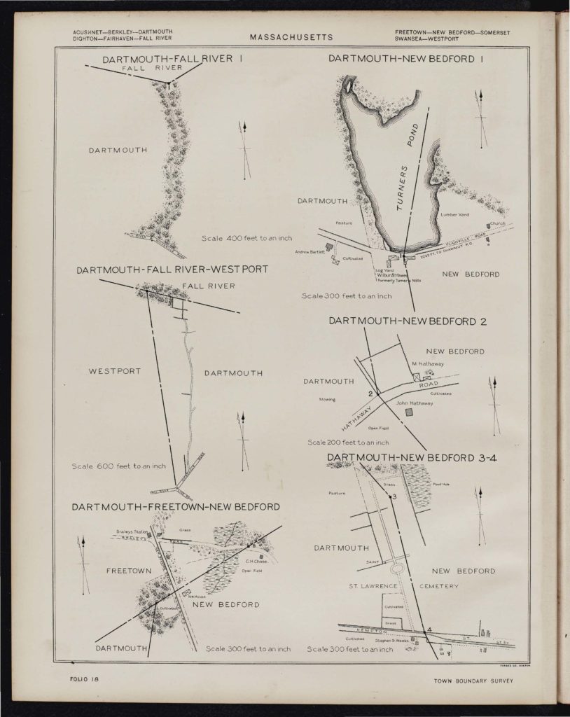
CORNER OF DARTMOUTH – FALL RIVER-WESTPORT.
(For sketch see folio 18.)
LOCATION. – The corner is situated in a wall surrounded by a heavy growth of woods, at a point about 2 -3 of a mile north of the junction of the F all River and New Bedford roads with the Westport road; it is approached by a wood road leading northerly from the Hicksville or New Bedford road, at a point about 300 feet from the above-named junction.
MARK. -The corner mark is a rough split granite monument, triangular in section, 4.25 feet in height and averaging 10 x 14 x 10 1/2 inches in section. The letter W is cut on the south face, F R on the northwest face, and D on the east face, all reading from the top downward.
DARTMOUTH- WESTPORT 1 AND W.M.
LOCATION. -The corner is an unmarked point at the intersection of the center line of the Dartmouth- Westport line road with the southerly side line of the road between Fall River and New Bedford. It is north 52° 45′ east and 29 feet distant from the witness mark, which is situated at the southwesterly corner or the two roads, being 6 feet from the westerly end of the culvert at that point.
MARK. – The witness mark is a rough split granite monument 4.75 feet in height and about 9 x 10 inches in section; it has stones piled around its base. The letter W is cut on the west face and D on the east face
DARTMOUTH – WESTPORT 2 AND W.M.
LOCATION. – The corner is an unmarked point in the center of the Dartmouth Westport line road, north 52° 45′ east and 27.5 feet distant from the witness mark, which stands on the westerly side of a wall, on the westerly side of the road, about one mile south of the junction of said road with the Fall River and New Bedford road.
MARK. – The witness mark is a rough split granite monument 4 feet in height and about 8 x 9 inches in section. The letter W is cut on the west face and D on the east face.
DARTMOUTH – WESTPORT 3 AND W.A (For sketch see folio 22.)
LOCATION. – The corner is a n unmarked point in the center of the Dartmouth – Westport line road, about 88 feet from the high-water line of Buzzards bay and about 20 feet east of the witness mark which stands 2.5 feet east of the wall on the westerly side of the road, at a point where the road turns westerly along the shore toward Gooseberry Neck.
MARK. – The witness mark is a rough split granite monument of irregular shape, 3·7 feet in height and about 9 x 10 1/2 inches in section. The letter W is cut on the west face and D on the east face.
DARTMOUTH – WESTPORT 4. (For sketch see folio 22.)
LOCATION. – The corner is an unmarked point in the low water line of Horse Neck beach, in the center line of the Dartmouth – Westport line road produced southerly.
CORNER OF FALL RIVER-TIVERTON – WESTPORT (For sketch see folio 28)
LOCATlON.- The corner is situated in a young growth of woods, at the line of highest water, at the extreme southern point of Sawdy pond, on land of Clarinda Potter ; it is about 850 feet north of the Westport road, at a barway, about 500 feet west of the house of Godfrey Tripp in Westport.
MARK. – The corner mark is a granite monument roughly hammered, 2.5 feet down from the top, 3.2 feet in height and 8 x 8 inches in section. The letters R. I. are cut on the west face, MASS. on the north and east faces, and R. 1. 1861 on the south face.
FALL RIVER – WESTPORT. (For sketch see folio 28.)
LOCATION. – The corner is situated on land of Stephen Borden, 2 feet south of a line of wall, on the southerly side of a cart road leading westerly from the East road near David Pettee’s house, and is about 450 feet east of the easterly shore of North Watuppa pond.
MARK. -The corner mark is a rough granite monument 2-4 feet in height and 7 x 10 inches in section. The letters F R are cut on the north face, and W on the south face.
FALL RIVER – WESTPORT 2. (For sketch see folio 28.)
LOCATION. – The corner is an unmarked point in the water space of North Watuppa pond, 2,380 feet due west of Fall River – Westport
FALL RIVER- WESTPORT 3. (For sketch see folio 28.)
LOCATION. – The corner is situated on the southerly side of Pleasant street, at the center of the stone arched bridge over the channel connecting North and South Watuppa ponds, and known as “the Narrows ” ; it is built into the parapet wall, the base of the stone forming the keystone to the arch of the bridge. There is a similar stone at the northerly end of the arch.
MARK. – The corner mark is a light-colored granite monument with rounded edges, 3.2 feet in height and 16 x 24 inches in section, dressed one foot down from the top. The letters F R are cut on the west face, W on the east face and 1896 on the north face.
FALL RIVER – WESTPORT 4. (For sketch see folio 26.)
LOCATION. – The corner is an unmarked point at the southern extremity of South Watuppa pond, at the mouth of Stony brook.
FALL RIVER – WESTPORT 5
LOCATION. – The corner is an unmarked point in the center of Stony brook, at the northerly extremity of Sawdy pond, which is about 1425 feet south of the road from Bliss F our Corners to New Bedford.
CORNER OF LITTLE COMPTON – TIVERTON – WESTPORT.
LOCATION. – The corner is an unmarked point on the Massachusetts – Rhode Island boundary line where the northerly line of Little Compton and the southerly line of Tiverton intersect the same, being about 3/4 of a mile north of the village of Adamsville. Its exact location is unknown.
LITTLE COMPTON – WESTPORT l. (For sketch see folio 30.)
LOCATION. – The corner is situated on the northerly side of the New Bedford road at Adamsville mill pond, near the westerly end of the dam, at a point about 450 feet easterly from the junction of said road with the road leading from Adamsville to Westport Harbor.
MARK. – The corner mark is a granite monument 2 feet in height and 7 x 8 inches in section, set in concrete masonry. The letters MASS. are cut on the east face, R.I. on the west face and 1898 in the top.
LITTLE COMPTON – WESTPORT 2. (For sketch see folio 30.)
LOCATION. -The corner is situated 2.5 feet west of a wall on the easterly side of the Nootas Hill road leading from Adamsville to Westport Harbor, at a point about 2,000 feet southerly from the junction of said road with the Adamsville – New Bedford road.
MARK. – The corner mark is a rough granite monument 2.8 feet in height and 7 x 9 inches in section. The letters R. I. are cut on the west face, MASS. on the east face, and 1898 in the top. The lettered faces are dressed, the others being rough hammered.
LITTLE COMPTON – WESTPORT 3 (for sketch see folio 30.)
LOCATION. – The corner is situated on high upland, 2.5 feet south of a wall on the northerly side of the Little Compton road, at a point about 1/4 of a mile west of the road leading from Adamsville to the southwestern part of Westport.
MARK. – The corner mark is a rough granite monument 2.5 feet in height and 7 x 8 inches in section. The letters R.I. are cut on the west face and MASS. on the east face. The lettered faces are dressed, the others being rough hammered.
LITTLE COMPTON – WESTPORT 4 AND W.M. (FOR SKETCH see folio 30.)
LOCATION. – The corner is an unmarked point at high water line at the Atlantic ocean, south 3° 20′ east and about 785 feet distant from the witness mark, known as “Peaked Rock” bound, which is situated in open pasture, on land sloping westerly from the southerly end of Quicksand pond.
MARK. -The witness mark is a light-colored granite monument 3.5 feet in height and 12 X 12 inches in section, dressed 3 feet down from the top. The letters R.I. are cut on the west face, MASS. on the east face, and 1898 on the south face.
TIVERTON – WESTPORT I.
LOCATION. – The corner known as the “Joe Sanford Bound” is situated in an orchard, 5 feet west of a wall and 125 feet north of the northwesterly corner of A. E Snell’s barn.
MARK. – The corner mark is a granite monument 2 feet in height and 8 x 8 inches in section, set in concrete masonry. The letters MASS. are cut on the east face, 1861 RI on the west face, and the figures 1898 on the top.
The statutes defining the present boundaries of this group of towns, the material parts of which are printed at the end of this preface, are as follows:-
1664, June 8, Plymouth Colony Records
1651- 1668, – incorporation of Dartmouth.
1668, March 5, Plymouth Colony Records
1683, July – , Plymouth Colony Records
1712, May 30, Court Records
1787, Chapter 9,-westerly part of Dartmouth incorporated as Westport. (Not printed.)
1787, Chapter 60, – easterly part of Dartmouth incorporated as the town of New Bedford.
1802-3, Chapter 89, – incorporation of Fall River.
1828, Chapter 70, – line between Dartmouth and Westport changed.
1847, Chapter 60, – New Bedford incorporated as a City. (Not printed.)
1854, Chapter 257, – Fall River incorporated as a city. (Not printed.) Accepted by the town April 22,
1861, Chapter 187, – act in relation to Rhode Island boundary.
1883, Chapter 113, -act to define boundary line of tide water between Massachusetts and Rhode Island.
1894, Chapter 478, – act to define the boundary line between the city of Fall River and the town of Westport. Report of Topographical Survey Commission on Fall River- Westport line.
1899, Chapter 476, – boundary line between Massachusetts and Rhode Island established.