
Maritime Activities
Posted on June 28, 2014 by Jenny ONeill
Maritime activities in Westport were necessarily centered around the coastal region, although the deep reaches of the Westport River allowed shipbuilding and other activities to occur well into the central portion of the town. This research category includes shipbuilding as well as offshore activities such as whaling, fishing, and coastal trade that relied on Westport residents for labor, operated out of town ports, or both. Maritime facilities and coastal modifications such as a lifesaving station, lighthouses, jetties and wharves, and bridges are also included in this research category. Many of these resources are related to other maritime activities, or to residential and/or commercial development along the coast. Other improvements such as seawalls, public and private beaches, and recreational facilities may also be included within this category.
Some of the earliest maritime activities in town were not tied to shipbuilding, but rather to the development of ports and landings to ship and receive goods for the area’s residents. Early proprietors of the town settled near coastal waterways and along both branches of the Westport River to insure passage from one community to another in the period before extensive road networks. The import and export of goods, known as “coasting” became extremely popular in the eighteenth century and helped some of Westport’s residents gain fame and fortune.
Shipbuilding, fishing, whaling, and coastal trading dominated the economy of Westport from 1770 to 1870, and these activities are most closely associated with the Head of Westport and the Westport Point area. A landing and ferry were constructed at Westport Point by 1712, and the early mill sites at the Head were augmented in 1795 by William Rotch’s ship supply works.
At the Head of Westport, shipbuilding was focused on the west side of the landing with at least one ship, the Phebe, built on the east side. Winslow Gifford’s boat works were located here (Macomber 2003). At one point, there were 20 whaling captains at the Head (N. Judson, personal communication 2003). The previous mill channel at the Head provided enough depth for large ships to be built and launched from the yard.
Shipbuilding also occurred on a smaller scale at the Hix Bridge area around the mid-eighteenth century. Among those vessels produced in the early nineteenth century was the Phoenix, a 110-foot (ft)-long ship of 423 tons (N. Judson, personal communication 2003). At least three shipbuilders operated at Hix Bridge; Lemuel Milk (Milke), John Avery Parker and Parker’s brother-in-law Levi Standish. Parker’s shipyard turned out 15 vessels during its period of operation (N. Judson, personal communication 2004). Tripp’s boatyard was located near Paul Cuffe’s ship works on Drift Road. Tripp’s yard was later moved to the Point and then finally relocated to its present location at Horseneck in the twentieth century (Smith et al. 1976:32). Local historical sources suggest that another member of the Tripp family moved its shipyard from Main Road to its current location (B. Wyatt, personal communication 2004).
Westport Point was primarily utilized as a provisioning area and homeport to fish and whale boats. The harbor was well known to the area’s captains as one of the most protected waterways in the region. One of the earliest recorded sloops out of the Point was the Union, which sailed in 1775. Throughout the eighteenth century, Westport’s men were engaged in the cod fishery from Nantucket to Newfoundland.
By the 1820s, New Bedford had eclipsed Nantucket to become the center of the commercial whaling industry and drew captains and crew from all of the neighboring towns, including Westport. Whaling voyages set out from the Point as early as 1806, but the period between 1835 and 1857 marks the height of Westport’s whaling industry involvement, with more than two dozen vessels sailing from the port (Hall and Sowle 1914). Coasting was also popular, and several vessels including the schooner Yankee brought supplies into the harbor to outfit the Point’s whaling ships.
As whaling began to dominate the economy of Westport Point in the early to mid-nineteenth century, development around the main wharf and throughout the village occurred rapidly. Blacksmiths, coopers, rum-makers, tailors, shoemakers, ship carpenters, sail and rope-makers, saltworks and sawmills sprang up in the area to service the needs of the incoming and outgoing ships. The Point also served as a temporary storage area when whale ships returned; an account taken in January 1860 records 1,100 barrels of sperm oil and 250 barrels of whale oil at the docks (Hall and Sowle 1914:33).
Archaeological deposits relating to this research context could include the remains of buildings, foundations, and work areas along the waterfront where shipyards are documented in the cartographic record. Portions of the ca. 1800 Lee’s and Cory’s wharves are still extant and both structures are included in the Westport Point National Register District (Wertz et al. 1992:12–13). Shipwreck sites or grounding areas could also be located off the Westport coast, and could include not only structural materials but also lost cargo and ballast.
Wharves, jetties and other extensions were present all along Westport’s waterways from the harbor to the upper reaches of the Westport River. Town landings were vital to Westport’s survival and were used throughout the historic period to receive goods brought by ship as well as to transport Westport products to other sections of town and outside of the community. At least nine of these landings are known to town historians and were located at Hix Bridge, Head of Westport, Westport Point, Pine Island, Adamsville, Cadman’s Neck, Emma Tripp’s Landing (on Horseneck Beach), Watuppa (Briggs Road), and Horseneck (N. Judson, personal communication 2003). Structural evidence of some of these landings is still clearly visible, as is the case at the Head of Westport. Other town landing sites may not be as well known or documented, and may contain archaeological deposits including the remains of wharves, jetties, and/or small building foundations.
Remnants of wooden and stone features may survive along the protected shoreline in these areas,
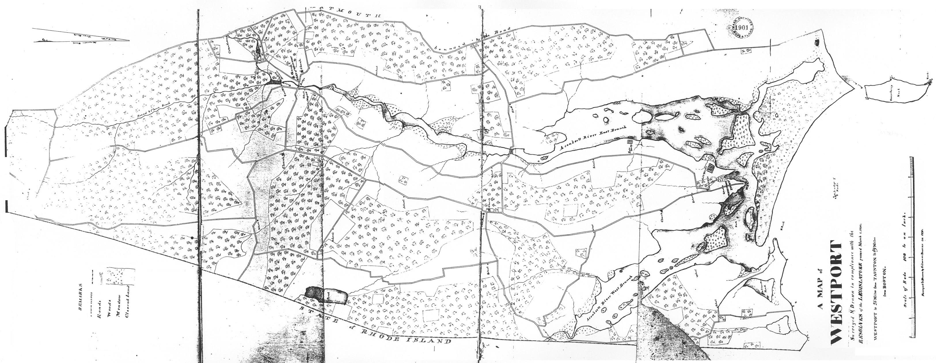
Map of Westport, MA in 1830 (source: Bourne 1831).
as well as under the current waterline. The 1830 map of Westport depicts the developing wharf complex at Westport Point, and smaller structures are shown at the mouth of the West Branch east of Cockeast Pond and to the north near Sanford Flat.
Indications of historic period coastal modifications may no longer be present along the southern coastline and in parts of the harbor at Westport Point, due in large part to the destructive effects of the 1938 Hurricane. Many coastal and near coastal sections of southeastern Massachusetts were completely altered by this massive storm, which wiped out most traces of structures and improvements in its path.